Property and Prices

Like many villages, Balsham has seen an increase in development over the years, with the inevitable rise in prices. Sales particulars show the vast different between 'then and now'.

In February 1889,  3 cottages, with shed, stable and a range of out buildings changed hands for £65.  

In 1903 a property abutting the High Street, plus a piece of land in 'Broadfield' measuring 3R 14P was let for an annual rent of £13. 12s.

In the 1960's and 1970's quite a lot of development took place. A 2-bed-roomed semi-detached bungalow would cost around £3,150; a 3 bed-roomed semi-detached house was selling for around £4,750. Detached  properties commanded a slightly higher price.  

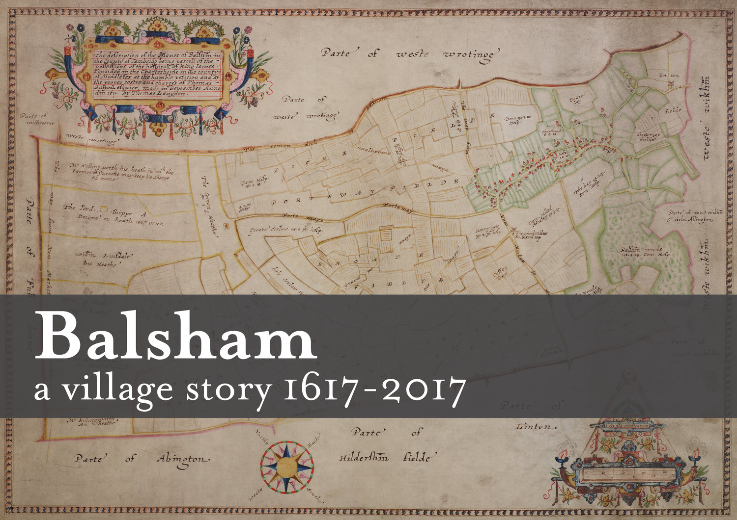
The original 1617 map shows us who rented or owned the land where some of these modern day developments now stand. Old House Road shows Wm and Thos Simon were there 400 years ago. Similarly, Trinity Close is on the site of a former Manor House; Sleford Close on land occupied by Ric Marshe.  Dolls Close by Edm. Marshe and Princes Close by Jo Haylock.

Further developments are planned for 2017 on land previously occupied by Ric Marshe and  Ro Cranfield, also on part of a site shown as Hornygate.  What prices will they fetch?


Arrival at 2017

The layout of our book is taking shape as we near completion of our project. So what has been discovered of the past four years?

It is surprising how much has been written about our village in days gone by.  Census records have come up with surprising facts and figures.  Newspaper reports contain interesting stories of our predecessors, also details of when houses and land were bought and sold.

Modern day cartographers are able to overlay old maps onto modern maps to show if boundaries have changed. Basically the layout of our village remains the same.  The original map is extremely accurate.

So what of the man who was commissioned by The Governors of Charterhouse to compile the original map in 1617?  Thomas Langdon was a Tudor cartographer and Oxford University alumni.   Five sheets comprise the map (some damaged). They are beautifully decorated.  Thomas was paid twenty pounds for his work.

The Big Sort Out!

As we reach the end of 2016 the vast amount of material gathered over the last few years needs to be sorted into an appropriate and manageable order.  This will take priority in the New Year. There are so many interesting articles coming in, the task will not be easy.

Early in the New Year we celebrate Balsham Plough Monday on 9th January 2017.  For anyone unfamiliar, Plough Monday is traditionally the first Monday after Epiphany or Twelfth Night.

The Balsham Ploughmen are a group of men who live in, or are connected to the village and they raise money annually for charities in Balsham by pulling an old-fashioned plough around the village, accompanied by the Cambridge Morris Men.  This year they will start at 5.30pm at West Wickham Road/Rosy Green end of the village, finishing at The Bell approximately 10.0pm.  For full information on their activities contact balshamploughmen@aol.co.uk 

WISHING EVERYONE A PEACEFUL CHRISTMAS AND HAPPY AND HEALTHY NEW YEAR.


Hedgerows and Boundaries

The old hedgerow boundaries were well documented at the start of our project.  As you cross the A11 road towards Balsham the 30 metre wide belt of beech trees with hawthorn hedges planted by Charterhouse of London, come into view.;  at Dotterel, records show that migrating 'Dotterel' birds roosted here.

The west and east hedgerows lining Fox Road contain, hawthorn, blackthorn, elder, rose, ash and apple. Similar species occur to the north east of the village. In recent times new developments have incorporated the same hedgerow species with the addition of Scots pine, oak and holly. During the last 10 years a beech and hornbeam hedge has been newly planted and provided another boundary.

The hedgerows continue to provide borders and boundaries between neighbours and farmland, which provide a vital wildlife haven.

Chasing Windmills

It is sometime since our Exhibition which formed part of the Balsham Feast Day.  Alongside the maps were displayed old photographs and parish records, plus a special feature about the Balsham Boys who joined up in WWI.  There was a steady of stream of visitors throughout the day.

One lesson learnt when looking at our maps has been to take note of the land  sizes as they exchanged owners.  This came in particularly useful when tracing one of two windmills in Linton Road, mentioned in a document dated 12th October 1753, which could easily have been lost and forgotten!


Balsham Feast Day 2nd July 2016

As Feast Day approaches preparations  are underway for our exhibition in the Church Institute from 10.00am to 5.00pm.

We have reached the 1960's when the new developments started to be built in the village. Come and see what a mortgage of £3 - £4,000 would buy!

There will be lots of other attractions taking place during the afternoon and evening, on and around the Recreation Ground.  Programmes for the event are on sale in Balsham Post Office for £2.

Wishing for warm and sunny weather on the day.

Forthcoming Display at the Balsham Feast Day

We are starting to arrange the layout for our book 'Balsham 1617-2017, a Village Story in Maps.' Once again we will be holding a small display of our work at the Balsham Feast Day, Saturday 2nd July 2016.

Come and see what was proposed in the 'Draft Village Plan' of 1972. issued by the then County Planning Officer, Cambridgeshire and Isle of Ely County Council.  Did it all come to fruition?

Pay us a visit, we will be in the Church Institute from 10 am, so you will have a chance to call in before the main event of the day opens on the Recreation Ground at mid-day.

Balsham 1617 - 2017 A Village Story in Maps

We have agreed on a title for our book.  'Balsham 1617 - 2017 A Village Story in Maps '.

A great deal has been written about the past, and, as we approach the final stages of the project we  sought  stories from people living in the village in more modern times.  Here are just a few :

 From a farmer in 1950, water from the deep well was pumped to the farmhouse and all the cottages every night, besides 60 cattle and 200 pigs. Electricity was not installed until 1958, mains water in 1975.

Once known as Oxcroft Lane as it led towards Oxcroft Farm, an old manor in the parish of West Wratting, the route took on greater importance from the C19th, when it replaced Fox Road as the more popular route from Walden to Newmarket.

The tall poplars planted by my parents and for so long in my life a landmark of home, visible for miles away, were felled this year.  The old iron estate fencing that I remember from  my childhood is long gone, as is the old gate into the orchard where the grass tennis court used to be.

When we first moved to Balsham in 1967 (two days before Christmas) it was a great delight to enjoy the country having  lived in London for 18 months in a basement flat.  The sun was shining into the house on our first Sunday morning was a real joy.


Poles, roods, perches, chains and acres

We have been transcribing the land measurements from the original 1617 map. So, what did one of these plots of land look like?  How big was it? How much for instance,  did Widow Lettice Marshe need to cultivate? She held 2 r (roods) 20 p (poles) + 19 a (acres) 1 r (rood) 36 p(poles) of arable land?

The only comparison we have in the village are the modern day allotments.  Therefore, we are  organising a 'Measuring Day',  just to see how much land Widow Marshe had to deal with.

We'll keep you posted.


16th February 2016

We are two years into our project and this year we will bring together all our information, and are seeking modern day contributions to bring the project up-to-date.  Through the centuries a great deal of information has been gathered from the  census, sales records and the maps themselves.

One building, a picture, painting or engraving that eludes us is, the large house which stood on the site of the present day May's Avenue. We believe this to be the home of Thomas Prince (Surgeon), the 1885 maps shows this to be 'nearly all  pulled down.'  Can you help?  Do you have a picture lurking in an old family album?

Philomaths

Archivists in Cornwall have revealed a new (old!) map of Falmouth which was drawn by George Withiell in 1690.  Last seen by the public in the 1880’s, the map was found in a private collection and has been donated to the Cornwall Record Office for display.

The Killigrew family of Mylor commissioned the map, called ‘A True Map of all Sir Peter Killigrew’s Lane in the Parish of Mylor and part of Budock Lands’, to show the land they owned. Money and property was the reason why Thomas Langdon was employed by London Charterhouse in 1617. However, Langdon was a surveyor by trade, part of a noteworthy, knowledgeable group of scholars. In contrast, Withiell was a philomath who mapped areas around Penryn and Holsworthy. A philomath is defined as a seeker of knowledge, facts and lover of learning, largely in the areas of humanities and maybe a specialist in one field.

Perhaps the map team are destined to be philomaths! We’ll let you know if we find anything exciting on our research into the village archives.

 http://www.bbc.co.uk/news/uk-england-cornwall-35443760?SThisFB%3FSThisFB

Planning the route to publication

The team met up this evening to plan out the book. Content is very important, after all we are aiming to produce a great publication that will record our village from 1617 to 2017, but so is the planning. We’re lucky to be supported by some professionals and we have learnt that how we approach this project is critical to it’s success.

Using their lessons learned and experience, we’ve created a subject list and thought about the feedback you have given us at our exhibitions. We have lots of wonderful houses in the village and we will write about those, but we are also going to look at the sites where new houses have been built too. We’ll explore shops, transport and the affect of the wars too, the church and celebrations.

Our fledging author team has been established and tasked with writing a draft 100 word pieces for our February meeting. We are also seeking an experienced editor with skills in Harvard referencing styles to aid us later in the year. If you can help, please get in touch!

January 2016

HAPPY NEW YEAR FROM THE MAP GROUP.  As 2016 dawns we are nearly two years into our project.  Little did we realise when embarking on this journey where it would take us.

How do we formulate all the material we have gathered? This coming year we start to collate the maps, pictures and written work we have accumulated.  How many pages will our book contain? This year we aim to find out.

We are still in the process of transcribing the original parcels of land shown on Thomas Langdon's original 1617 map.  Some names still appear on the 1910 Land Tax records for the village..  Are they from the same family? A tentative look at early records shows a John Killingworth (1617) of a near- by village of Pampisford,  is he a very distant relation of John KIllingworth a shepherd living in a 5 bedroom house in Linton Road in 1911? This opens up another avenue of investigation! 

WE WOULD LIKE TO THANK THE BALSHAM PLOUGHMEN  who have kindly included us in their fund raising celebrations on 11th January Plough Monday.  If you have not witnessed this cololurful and lively event,  why not come along?  Starting at 5.00pm in the Cambridge/Linton Road area, the Ploughboys', accompanied by the Cambridge Morris Men will be pleased to see you as they proceed through the village during the evening.

December 2015

What happened to November?

These snippets are taken from the Parish Magazine of the Camps Deanery for Christmas 1911. Courtesy of the Cambridge Collection.

Over the festive season all the school children and some others came at the invitation of the Rector and Mrs Burrell to a tea and Christmas Tree (in the school). The Christmas Tree was supposed to be a surprise, and many of the children were astonished and audibly expressed their delight when the sliding doors of Schoolroom were withdrawn and the tree shone forth in all its bravery of light and decorations.   There were presents for all.

On Boxing Night, a social evening was held in the School, which was attended by a very large number of Balsham people and by several from neighbouring parishes. Dancing Games and songs were included in the evening's programme. The proceeds, which amounted to £2. 1s. 6d. were given to the Church Institute Fund.

Wishing you all a peaceful and pleasant Christmas from the Map Group.


Why walk a boundary?

The Great Balsham Boundary Walk 2015


The idea for Beating the Bounds of the village to raise funds for the new Community Room in the Church and for the Balsham Map Project came about in late Summer of 2014 with Dick Paden and Peter Neale volunteering to organise the event.


Beating the Bounds is a custom dating from Anglo Saxon times and still enshrined by law to permit the priest and church wardens accompanied by the young boys of the parish to beat the parish boundary markers (and also sometimes the boys themselves!) with green willow boughs to make them remember. The event, usually held in Rogation Week, was to ensure that the boundary knowledge was passed on to younger generations and that land had not been taken by the neighbours thus reducing the taxes payable to the church. Prayers and blessings for the lands and harvest were part of the custom and accompanied by much revelry and celebrations. Since 1860 the Bounds can only be legally beaten every third year or longer.


It was quickly decided that we didn’t need to beat young boys and a simple clockwise perambulation of the boundary would make a great day’s walk and so the Great Balsham Boundary Walk was born.  Peter, with his local farming knowledge, was the key player in contacting local land owners to seek their permission to walk the boundary over their land.


After many months of planning, finally, on Sunday Sept 6th in glorious weather 107 walkers (and over 20 dogs!) Beat our Parish Boundary to raise money for the toilets and community room in Holy Trinity Church and to support the Balsham 1617 Map Project. This project will celebrate in 2017 the first detailed map of the village compiled in 1617 by publishing a commemorative historical book for every household in the village. Walkers were across the full age range with many coming from Balsham but there were also good numbers from adjoining villages who had seen our posters.


The boundary of the parish is over 13 miles long, encompasses sections of the Fleam Dyke and the Roman Road and on that sunny day gave stunning views over Cambridgeshire with the unique opportunity to walk over private land and also visit the highest point in the county!


There were three walks of differing lengths all starting at the Institute and more than 25 walkers completed the full distance with the fastest taking well under 5 hours . The entire route was off road and was signed and marshalled by volunteers with the use of radios from the Cambridgeshire Raynet Group.


The organisers are especially grateful to all those who took part either walking or in the many supportive roles and in particular those landowners whose land the parish boundary crosses and not least of all those sponsors in time and money – their contributions made this event such a success.  The total raised to date exceeds £1300.

Dick Paden

12th Sept 2015
DAY AFTER THE WALK!

Monday 7th September

The weather people certainly  got the forecast right for yesterday, we had  glorious  sunshine all day over Balsham;  perfect walking weather!

107 walkers and around 20 dogs set off on the various routes and got back safely. 20 decided on the long walk, and well done to them.  It looks as if we have raised just over £1,000 to be shared between  the two organisations.  Thank you to all those who took part and everyone else who helped to make this a successful day.

Pictures of the event are being gathered and will appear soon.

Striding forward!

It is the night before the walk and tomorrow promises to be a fine day, this from the BBC Weather:

Dry for most with variable amounts of cloud and some sunshine. With light winds, it will feel quite warm in the sunshine:

We would like to say thanks to our supporters and helpers:

Rotary Club of Sawston for signage and hi-vis clothing
Cambridge Raynet Group for safety radios and advice
Alan's Ark for dog treats
Black Bull for sponsoring route maps
Cheffins for providing refreshments
 
and our advertisers:
Squeaky Mouse
Dramawise Sawston
Capri Blinds
Reardon and Co Chartered Accountants
Alex Talbot Tree Surgeon

Most of all you, for taking part! Do post your photos on Twitter and tag or follow us @BalshamMap.


6th August 2015

The Great Balsham Boundary Walk is fast approaching.  The majority of the walk is on public rights of way, however, part of it goes across private land, courtesy of the owners, and will be open for this event only.

Based on Thomas Langdon's  1617 Balsham Map, those taking part will be following in the footsteps of the early cartographers.  More of the  beautifully detailed early maps will be on display at the Church Institute, where the walk starts and ends.

At the Church Institute tea, coffee, fruit juice and biscuits are available.  However, if you wish for something more substantial, you may wish to contact The Black Bull Inn on 01223 893844 or  info@blackbull-balsham.co.uk 

Whichever route you choose, 4, 10 or 12.5 miles, please allow yourself enough time to be back to the Church Institute by 4.00 pm.

Every effort has been made to make the event run smoothly. Thank you for supporting us, we ask you to take care, but most importantly enjoy the day!